During a walk last year of the GR5 trail from Genève to Nice, I learned that the original came from a bicycle route: Grandes Alpes.

The GR5 part I walk in 2016 was only half way through the trail, to be completed in 2017. So it was set to arrive a week early before part II, bicycle the route, meet the group in Nice, & continue the walk.
I would have walked & bicycled the Route des Grandes Alpes.
Came back in September 2021 for Le Raid Pyrénéen challenge from Atlantic Ocean to the Mediterranean across the Pyrénées mountains.
Cols
List of 17 cols passed on this trip in 7 days:
| Day | Name | Elevation [m] |
|---|---|---|
| Friday 25 August 2017 | Col des Gets | 1,172 |
| Col de la Colombière | 1,613 | |
| Col des Aravis | 1,487 | |
| Saturday | Col des Saisies | 1,650 |
| Cormet de Roselend | 1,968 | |
| Sunday | Col de l’Iseran | 2,770 |
| Col de la Madeleine | 1,746 | |
| Col du Télégraph | 1,566 | |
| Monday | Col du Galibier | 2,642 |
| Col d’Izoard | 2,360 | |
| Tuesday | Col de Vars | 2,109 |
| Col de la Cayolle | 2,326 | |
| Wednesday | Col de Valberg | 1,672 |
| Col de la Couillole | 1,678 | |
| Col Saint-Martin | 1,500 | |
| Thursday 31 August 2017 | Col de Turini | 1,607 |
| Col de Castillon | 706 |
Lac Léman
It was a comfortable flight from Boston to Genève by way of Zürich, arriving on time at 7:45 on Thursday 24 August 2017.

Weather forecast was looking clear:

I had plenty of time that day to transfer to Thonon, pack for trip, shop for food, assemble bicycle, & mail extra luggage to Nice.

Then suddenly I did not have much time. In Genève, my luggage did not arrive. Assuming it did not make the connection in Zürich, I waited for the next plane. And the next plane. And the next one until 12:00. When the luggage still did not arrive, I decided to get some rest in hotel, nap, confirm post office location & hours, & prepare for quick transfer when the luggage did arrive.
The luggage did finally arrive at 16:00, with just enough time to transfer content, mail bag before post office closed at 18:00, shop for food, & pump bicycle tires before shop closed at 19:00. All was ready for the tour.

Gets-Colombière-Aravis
Getting out of town, immediately there was a sign that bicycles were not allowed on that section of D902 road. No choice except to continue. There was probably another route to take, more scenic, with less traffic. But not the time to explore.
A little while later, I started seeing other bicycles on the road. Route was better. Saw the first sign for Route des Grandes Alpes. Climbing started to the first col des Gets at 1,172m.

Signs of Tour de France came next on climb to col de la Colombière with road markers & racer names on the road.

Col de la Colombière at 1,613m:

After a long descent, I started the third climb to col des Aravis at 1,487m:

As if all this climbing of the first day was not enough, I had one last steep climb to my room at Hotel la Molliniere.
Saisies-Roseland
Climb started immediately. Two bicyclists passed me at reasonable speed. Still feeling fresh early in the day, I increased my pace to keep up with them. We stayed together to col des Saisies at 1,650m:

Big mistake. I was exhausted already while I still had Cormet de Roseland. Stopped at Lac de Roselend to rest:

Cormet de Roseland at 1,968:

Luckily, Tour L’Avenir bicycle race was on the same course. I was forced to evacuate the road for an extended rest ahead of the big climb.
Nightmare of the day came on climb to Val d’Isère. Being a weekend in vacation month of August, swarms of motorcycles were passing me. No rules of the road seemed to apply to them about speed, lanes, or safe passing of other vehicles. Pollution from noise & fumes was noxious at best. I was certain to tumble off the side of the mountain any moment.
A series of long tunnels close to town did not help my anxiety either:

Drivers seemed aware of bicycles on this popular road. They gave me plenty of space. Front & rear flashing lights on the bicycle helped keep me visible.
Iseran-Madeleine-Télégraph
Breakfast buffet was generous at Les 5 Fréres: yogurt, apricot jam, egg, cheese, meat, meüsli, milk, & bread.
I needed that energy to climb 13km to the highest col in France.

I took the long steep descent to Bonneval-sur-Arc: a small town with narrow streets, farmers market, bakery, goat cheese shop, old church, & war memorial.
From there, it was a very long, mostly boring, gradual descent through the valley, without much scenery, passing by col de la Madeleine at 1,746m:

On Sunday, almost every service was closed except for a small restaurant in Saint-Michele-de-Maurienne for water & juice.
Traffic nightmare continued on the climb to col du Télégraph at 1,566m:

More than motorcycles, all terrain 4×4 vehicles joined the swarm for a car show in Valloire.
Galibier-Izoard
Suddenly traffic vanished & the trip redeemed. Maybe because it was Monday & the crowd returned to work. Maybe because the villages were smaller without big resorts & do not attract big crowd. Or maybe it was the end of vacation season.
Time to Live Slow Ride Fast:

That was just in time for spectacular scenery for remainder of the trip: big mountains, wide valleys, steep gorges, & soaring roads to col du Galibier at 2,642m:

And col d’Izoard at 2,360m:

Earlier, I had met Tony & Brian from MIT Cycling Team. We continued together whenever I was able to keep up.
Refuge d’Izoard was more than just shelter from thunderstorm. There was a large display of pastries. It was hard to decide, so I tried three pieces: blueberry tart, pear tart, & lemon pudding:

Descent was through Gorges du Guil:

On a road carved in stone:

The route had several trash cans with backboards for bicycles on the move:

Vars-Cayolle
Today was exceptional: away from crowds & ski towns.
Climb to col de Vars at 2,109m:

The route entered Parc national du Mercantour on small narrow roads, carved in stone as a ledge on side of high cliffs:

Big mountains were in view throughout even when at a col de la Cayolle at 2,326m:

Valberg-Couillole-Saint Martin
Bakeries started to offer local Mediterranean cuisine.

First came col de Valburg at 1,672m. Few services & ski lifts were nearby.
Then col de la Couillole at 1,678m:

In Saint-Sauveur, it was the pissaladière: flat bread with cooked onion & olive on top. They also had tartelette aux blettes: sweet Swiss chard pie with raisins. I waited to try that later when on the GR5 hike.
Finally, col Saint-Martin at 1,500m with services, shops, & ski lifts nearby:

In Saint-Martin-Vésuvie it was abricot pistache tart with a rest stop in the square:

It was an active town with many shops & entertainment options.
Unfortunately, my hotel was further down the mountain in a loud town that had live music in the square until midnight. It seemed fun for residents who were dancing & drinking. It was not fun for a tired bicyclist who wanted to sleep early. Saint-Martin-Vésuvie would have been a better choice.
Turini-Castillon
The main thought on my mind was la grande plonge in the Mediterranean sea.
Sospel came after Col de Turini at 1,607m:

I stopped there two weeks later while hiking the GR5 for extended visit.
Two bakeries were near each other. I tried savory tartelette aux blettes, pissaladière, & brioche Suisse:

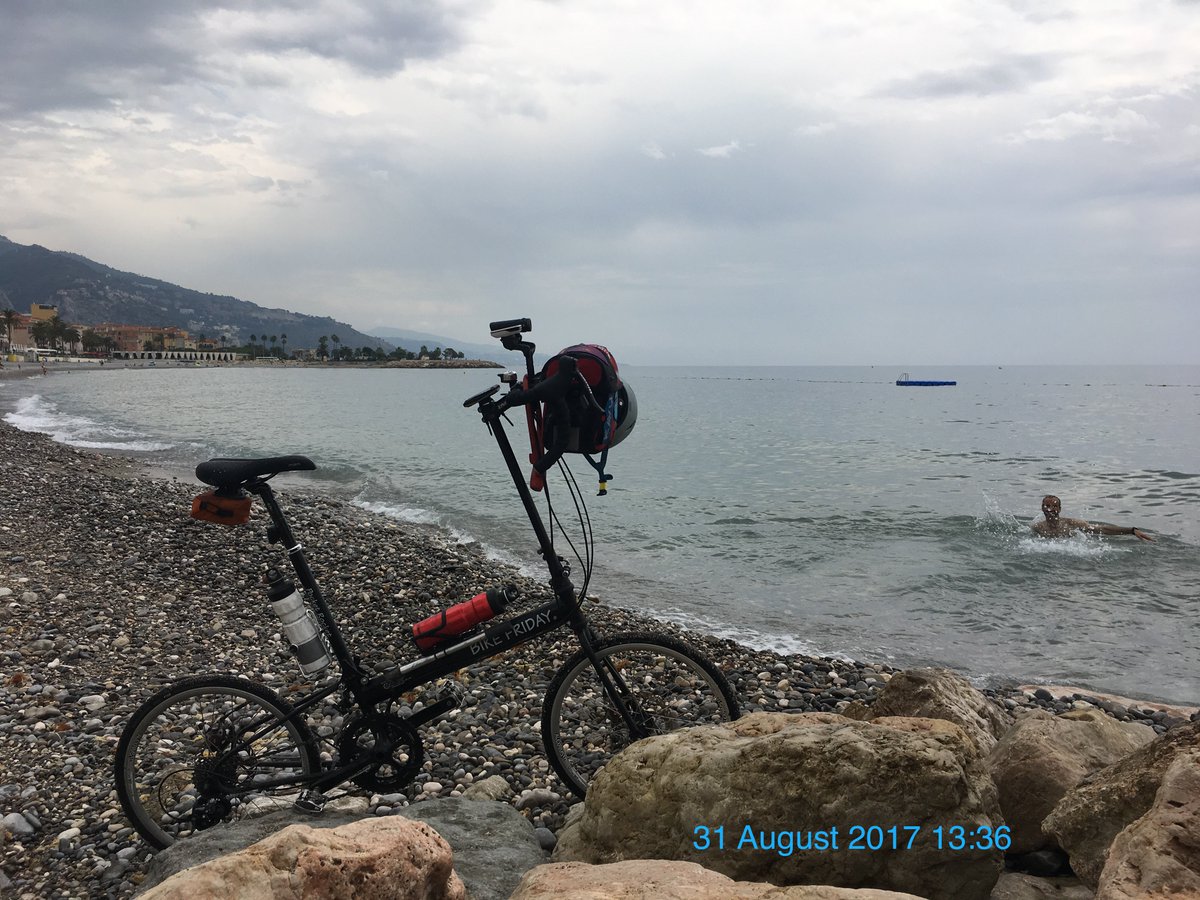
Final climb of the trip was to col de Castillon at 706m:

No stopping after that. It was a fast descent to the beach. Parked my bicycle. Jumped into the water:
Cote d’Azure
Entire day on the beach.
Soon after leaving Menton, I took a cliff walk along the rocky coast all the way to Monte Carlo, with constant views of the sea, mountains, & mansions.
Bicycle was not allowed on cliff walk. For good reasons: narrow, busy, & plenty of stairs. Even with light load on the bicycle, I got tired after a while carrying it up & down.
Monte Carlo was a collection of enormous yachts larger than small ships, expensive sports cars, & private mansions.
Nice had a bicycle path along the beach. Sun was bright. Sky was blue.

Nice was beautiful. I had arrived.
I spent the next two days tasting local bakeries, fresh fruits, & sweets from Marché aux Fleurs Cours Saleya.
Some pâte d’amande:

Some fruits confits glacés: clémentine & abricot:

Itinerary
| Route | Log |
|---|---|
| Transferred from Genève airport to city center Cornavin station, took bus 61 to Annemasse train station in France, took SNCF train to Thonon-les-Bain Lodging 30€ at Côté Chalet Résidence Hostel Used local post office in Thonon-les-Bain to ship bicycle case & backpacking gear to Nice. Cheaper to send them within country than from Switzerland. | 24 August 2017 |
| Col des Gets 1,172m Col de la Colombière 1,613m Col des Aravis 1,487m Bed & breakfast 53€ at Hôtel Restaurant Brasserie Laverie “La Mollinière” | 25 August 2017 8:03 Garmin & Strava ➡️119.09km ⏩13.52km/h 🔄8h48:39 ⬆️2816m ⬇️2102m ↗️23.6m/km 📶22.5ºC ⏬Ride with GPS |
| Col des Saisies 1,650m Cormet de Roselend 1,968m Bed & generous breakfast 52€ at Les 5 Frères | 26 August 2017 8:46 Garmin & Strava ➡️99.2km ⏩11.1km/h 🔄8h56:31 ⬆️2893m ⬇️2236m ↗️29.2m/km 📶22.7ºC ⏬Ride with GPS |
| Col de l’Iseran 2,770m Col de la Madeleine 1,746m Col du Télégraph 1,566m Bed & breakfast 79€ at Le Relais du Galibier | 27 August 2017 9:18 Garmin & Strava ➡️109.58km ⏩14.0km/h 🔄7h50:54 ⬆️2056m ⬇️2309m ↗️18.8m/km 📶24.3ºC ⏬Ride with GPS |
| Col du Galibier 2,642m Col d’Izoard 2,360m Bed & breakfast 30€ at Auberge de Jeunesse de Guillestre | 28 August 2017 8:06 Garmin & Strava ➡️102.72km ⏩14.6km/h 🔄7h03:04 ⬆️2248m ⬇️2747m ↗️21.9m/km 📶22.1ºC ⏬Ride with GPS |
| Col de Vars 2,109m Col de la Cayolle 2,326m Bed & breakfast 65€ at Gîte Le Pelens | 29 August 2017 8:46 Garmin & Strava ➡️101.64km ⏩13.1km/h 🔄7h44:49 ⬆️2283m ⬇️2198m ↗️22.5m/km 📶24.2ºC ⏬Ride with GPS |
| Col de Valberg 1,672m Col de la Couillole 1,678m Col Saint-Martin 1,500m Lodging 49€ at Hôtel des Sports | 30 August 2017 9:07 Garmin & Strava ➡️93.84km ⏩12.1km/h 🔄7h45:38 ⬆️2134m ⬇️2h534m ↗️22.7m/km 📶26.2ºC ⏬Ride with GPS |
| Col de Turini 1,607m Col de Castillon 706m Lodging US$97.64 at Quality Hotel Méditerranée booked through Hotwire | 31 August 2017 8:16 Garmin & Strava ➡️65.25km ⏩12.8km/h 🔄5h04:44 ⬆️1421m ⬇️2013m ↗️21.8m/km 📶21.9ºC ⏬Ride with GPS |
| Total | ➡️691.32km ⏩12.99km/h 🔄53h14:19 ⬆️15,851m ⬇️16,139m ↗️22.9m/km 📶23.5ºC |
| Daily average | ➡️98.76km ⏩12.99km/h 🔄7h36:20 ⬆️2264m ⬇️2306m ↗️22.9m/km 📶23.5ºC |
| Lodging 40.25€ at Villa Saint Exupery | 1 September 2017 8:19 Garmin & Strava ➡️37.35km ⏩6.2km/h 🔄5h59:01 ⬆️461m ⬇️443m ↗️12.3m/km 📶30.7ºC ⏬Ride with GPS |
Pack
Credit card tour: I carried very little gear, slept in hotels, & bought food along the way. Whatever I needed fit into the handlebar bag.
I washed day clothes in the evening to dry overnight. Whatever did not dry, I hung on the bicycle next day. This was often the case with chamois on bicycle shorts. I had another pair of bicycle shorts to use while the other was drying.
Below is a list of every single items, regardless of size or weight, that I had with me, on me, & on the bicycle.
- Bike Friday for all roads, travels easy, & reliable. It had been with me on plenty of trips.
- Water bottles ×2
- Front light: Light & Motion Urban, use it in flash mode for visibility during the day
- Wahoo Elemnt GPS: navigate & record trip data. Reliable, easy to use, & completely wireless
- Garmin Edge 820e GPS: record data for redundancy & compare with Elemnt
- Wahoo mount on stem
- Garmin mount on handlebar bag extension
- Saddle bag
- Handlebar bag
- Rear light: Knog Blinder with many flashing modes, stays on all day, bright light
- Pump
- Lock & key
- Saddle bag Ortlieb Micro water proof bag to keep the tools dry & avoid rust
- Patch kit
- Spare tube
- Tire levers
- Multi-tool: hex wrenches & chain breaker
- Handlebar bag Ortlieb Ultimate 6M+ with 7 liters capacity
- Tooth floss
- Tooth brush
- Tooth paste
- USB charger with four ports
- Mini USB charging cable
- Micro USB charging cable ×2
- iPhone charging cable
- Garmin Fēnix 5 charging cable
- Suunto Spartan charging cable
- USB battery: Goal Zero Flip 30 to charge phone, GPS, & lights as needed
- Wall electric outlet adapter for France
- Band-aid
- Hydration tables: Hammer Nutrition Race Caps Supreme 3–5 tablets per day
- Sun screen
- Notebook
- Pencil
- Chamois cream: Assos
- Running shorts: change into in the evening
- Rain jacket
- Rain pants
- Hat
- Shirt
- Rain shell mittens
- Booties rain socks
- Bicycle shorts liner
- CR2032 batteries ×2
- Mounting bracket for handlebar bag
- Front light Ortlieb extender for handlebar bag
- Me
- Helmet
- Heart rate monitor strap: Wahoo Tickr to work with both ANT+ & Bluetooth devices
- Gloves half finger
- Bicycle shorts liner
- Ankle cuffs for pants
- Sun glasses
- Mirror
- Long thin pants Arc’teryx Rampart to protect from sun, dry quickly from rain or sweat
- Long sleeve sun shirt
- Sandals Keen waterproof with SPD cleats
- Socks
- Fēnix 5 watch
- Suunto Spartan watch
- Waist pack
- Waist pack Arc’teryx Maka 2, versatile, spacious, multiple pockets, easy access while moving or walking into a store.
- iPhone
- Headphone
- Passport
- Lip balm
- Credit card
- Cash

Leave a comment